Geological Exploration Services
  • Home
  • What is LiDAR
  • LiDAR Coverage
    • LiDAR Coverage
    • NSW
    • Qld
  • The advantage of digital maps
  • Map Gallery
  • Products
    • Products
    • Location 1:250,000 scale
    • Location 1:25,000 scale >
      • Historical Parish Map
    • Farm Plan
    • DP Plan / Survey Plan
    • Orthophoto Map
    • Digital Elevation Model
    • Slope Map
    • Aspect Map
    • Geology
    • Soil Map
    • Landscape Map
    • Flow Accumulation
    • Water Catchment
    • Flow Direction
    • Revised Universal Soil Loss Equation
    • Erosion Potential
    • Flood Map
    • Vegetation
    • Canopy Height
    • Lidar Ground Point Density
    • Canopy Intensity
    • Tree Block Map
    • Tree Variety Map
    • 3D models
  • Prices
  • Contact
  • Using the maps for farm productivity
  • Examples
  • Downloads
Recording farm activities

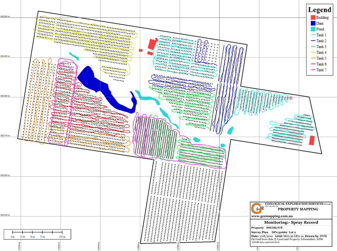
The map below displays a record of the location and time of spraying using the track record option on a map using PDF Maps on an android smartphone. The track is recorded in real time and can be observed on the screen during the spraying process.  The benefits include:-

  • Compliance 
  • Defining precisely where one tank finished and knowing where to commence the next load 
  • Defining limits of areas sprayed when spot spraying
  • Matched to weather records if the farm has a weather recording station
Picture
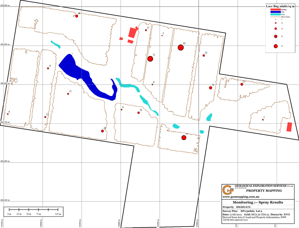
Monitoring the results of the spaying can be achieved by placing 1sq m mats on the ground prior to spraying and recording the number of target insects 12hrs after spraying. The location of mats was recorded using the Placemark option on a map loaded into an android phone using PDF Maps.
Picture
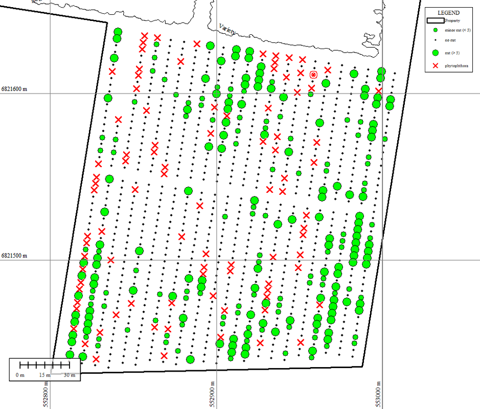
Monitoring results can be recorded on paper copies of maps of tree locations.
Picture
  • Home
  • What is LiDAR
  • LiDAR Coverage
    • LiDAR Coverage
    • NSW
    • Qld
  • The advantage of digital maps
  • Map Gallery
  • Products
    • Products
    • Location 1:250,000 scale
    • Location 1:25,000 scale >
      • Historical Parish Map
    • Farm Plan
    • DP Plan / Survey Plan
    • Orthophoto Map
    • Digital Elevation Model
    • Slope Map
    • Aspect Map
    • Geology
    • Soil Map
    • Landscape Map
    • Flow Accumulation
    • Water Catchment
    • Flow Direction
    • Revised Universal Soil Loss Equation
    • Erosion Potential
    • Flood Map
    • Vegetation
    • Canopy Height
    • Lidar Ground Point Density
    • Canopy Intensity
    • Tree Block Map
    • Tree Variety Map
    • 3D models
  • Prices
  • Contact
  • Using the maps for farm productivity
  • Examples
  • Downloads