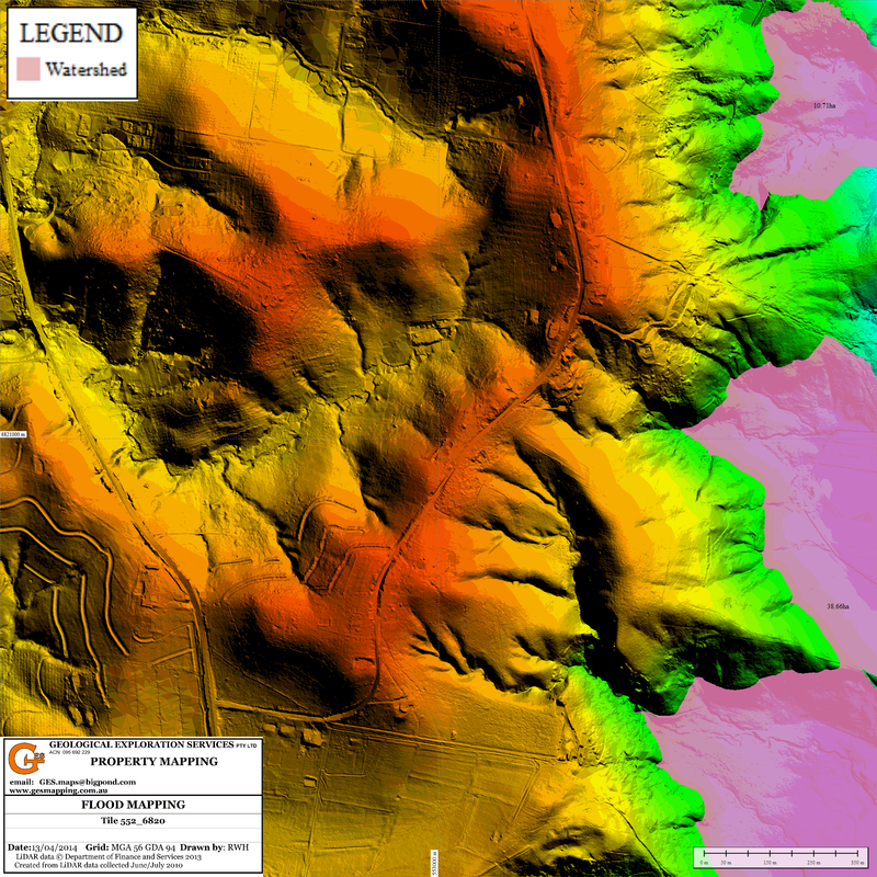
Geological Exploration Services
  • Home
  • What is LiDAR
  • LiDAR Coverage
    • LiDAR Coverage
    • NSW
    • Qld
  • The advantage of digital maps
  • Map Gallery
  • Products
    • Products
    • Location 1:250,000 scale
    • Location 1:25,000 scale >
      • Historical Parish Map
    • Farm Plan
    • DP Plan / Survey Plan
    • Orthophoto Map
    • Digital Elevation Model
    • Slope Map
    • Aspect Map
    • Geology
    • Soil Map
    • Landscape Map
    • Flow Accumulation
    • Water Catchment
    • Flow Direction
    • Revised Universal Soil Loss Equation
    • Erosion Potential
    • Flood Map
    • Vegetation
    • Canopy Height
    • Lidar Ground Point Density
    • Canopy Intensity
    • Tree Block Map
    • Tree Variety Map
    • 3D models
  • Prices
  • Contact
  • Using the maps for farm productivity
  • Examples
  • Downloads
Flood Map

The flood map shows the area which could get flooded if the water level rises to a particular elevation.

The map includes:-
  • DEM image
  • area covered by water (ha)
  • infrastructure (roads, buildings) 
  • surveyed property boundary
Picture
  • Home
  • What is LiDAR
  • LiDAR Coverage
    • LiDAR Coverage
    • NSW
    • Qld
  • The advantage of digital maps
  • Map Gallery
  • Products
    • Products
    • Location 1:250,000 scale
    • Location 1:25,000 scale >
      • Historical Parish Map
    • Farm Plan
    • DP Plan / Survey Plan
    • Orthophoto Map
    • Digital Elevation Model
    • Slope Map
    • Aspect Map
    • Geology
    • Soil Map
    • Landscape Map
    • Flow Accumulation
    • Water Catchment
    • Flow Direction
    • Revised Universal Soil Loss Equation
    • Erosion Potential
    • Flood Map
    • Vegetation
    • Canopy Height
    • Lidar Ground Point Density
    • Canopy Intensity
    • Tree Block Map
    • Tree Variety Map
    • 3D models
  • Prices
  • Contact
  • Using the maps for farm productivity
  • Examples
  • Downloads