Digital maps can be printed on paper, providing as many copies as one likes and at different scales and paper sizes. Digital maps can also be used on the computer and on mobile devises such as smartphones and tablets. Distances, bearing and areas can be calculated and annotations made on the map. On mobile devices with a GPS chip, your location on the map is displayed and locations and track movements can be recorded.
Details on how to use the maps on the computer or mobile devices can be found in the attached files:-
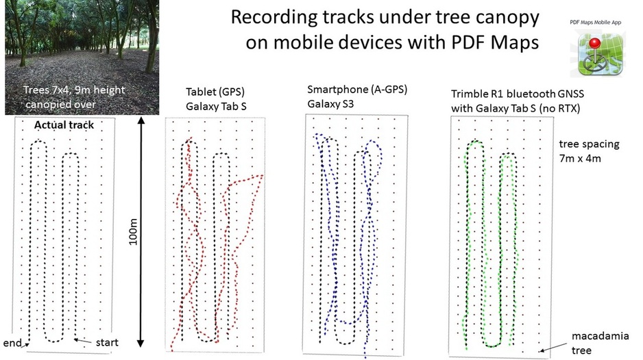
Improving GPS accuracy
The accuracy of GPS readings on mobile devices is generally in the 10-20m range but degrades beneath canopy cover. The readings improve with the addition of a cell phone chip and connection to a cellular network due to the use of A-GPS (assisted GPS) and can get down to a 5m accuracy. The new bluetooth GNSS receivers such as Bad Elf, iSX Blue, EOS Arrow and Trimble R1 have the ability to turn mobile devices into survey grade instruments with centimetre level accuracy.
Details on how to use the maps on the computer or mobile devices can be found in the attached files:-
Improving GPS accuracy
The accuracy of GPS readings on mobile devices is generally in the 10-20m range but degrades beneath canopy cover. The readings improve with the addition of a cell phone chip and connection to a cellular network due to the use of A-GPS (assisted GPS) and can get down to a 5m accuracy. The new bluetooth GNSS receivers such as Bad Elf, iSX Blue, EOS Arrow and Trimble R1 have the ability to turn mobile devices into survey grade instruments with centimetre level accuracy.